September Moisture Update
Alberta Government Update from your Rural Development Department
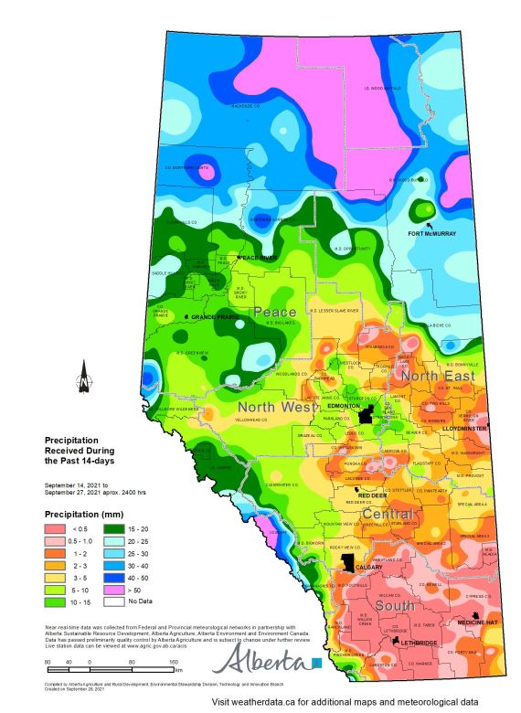
Synopsis (map 1)
Over the past two weeks rainfall has been variable, with less than 0.5 mm recorded across most of the Southern Region, many parts of the North East Region and to a lesser extent through the northern portions of the Central Region (map 1). In contrast the Peace Region has fared better, with upwards of 25 mm recorded through the north, ranging down to 10-15 mm in the south. Across the North West Region variability is high, ranging from less than 3 mm in some locations, up to 10-15 mm across the east.
As Fall is an important time for recharging soil moisture reserves, a wet October would be welcome and much needed across most lands.
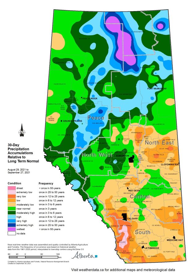
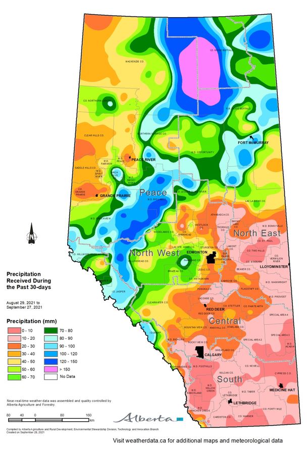
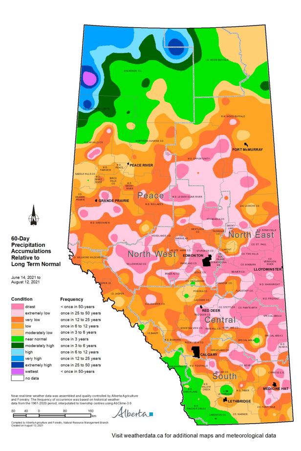
30-day precipitation accumulations as of September 27 2021. (map 2 and map 3) Over the past 30-days, generally warmer than normal temperatures have prevailed.
In addition, a drier than normal pattern has remained throughout much of the drought stricken areas in the North East and both the Central and Southern Regions (map 2 - left) with large areas receiving less than 10 mm of rain (map 3 - right).
Generally most of the lands across the North West and Peace Regions have received at least near normal moisture for this time frame (map 2).
Perspective (map 4 and map 5):
The growing season of 2021 was exceptionally hot and dry across Alberta’s agricultural areas with total precipitation accumulations estimated to be this low at least less than once in 12 years, and many estimated to be this low less than once in 25 to 50 years (map 4).
Note that for many locations, the growing season started out with promising rains so map 4 tends to under represent the acute lack of moisture that affected the agriculture industry this year.
In Mid-June conditions turned exceptionally dry, province wide, which coupled with warmer than normal temperatures and extreme heat, lead to reduced yields and chronic moisture stress as crops reached peak water demand through late June, July and early August. This left large areas with rainfall deficits experienced less than once in 50-years (map 5).
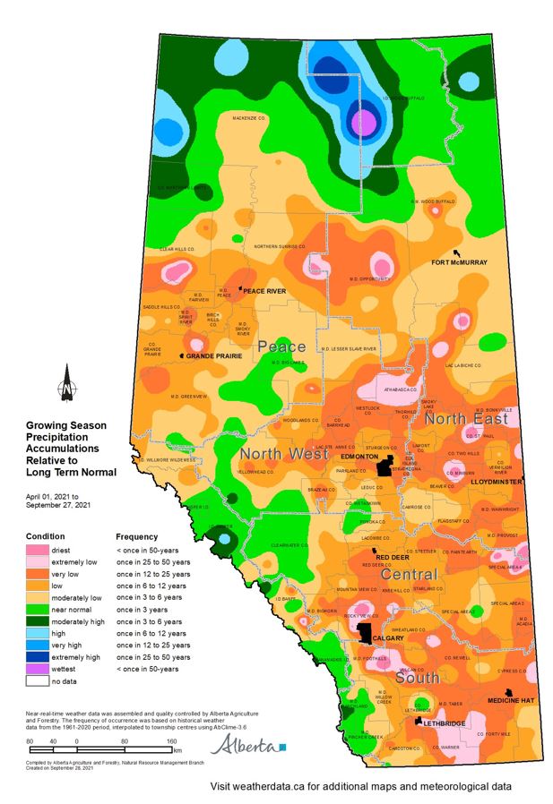
The droughts of the late 20’s and early 30’s culminated in up to 5 years or more of back to back dry growing seasons, often accompanied by long spells of plus 30 degree weather. This period during our relatively short meteorological record is significant and provides important insights into natural variability, underscoring the importance of developing resilience in our agricultural systems.
Fall rains are needed now, along with at least near normal moisture throughout the winter in early spring. However, if conditions remain dry this fall and over winter, soil moisture reserves can be recharged significantly if we have a wet spring, which is not uncommon in some years. Failing that, most crops will do well even without adequate soil moisture reserves, provided that near normal rainfall comes at the right times through June, July and into mid-August.
Contact Us
Saddle Hills
Junction of Hwy 49 & Secondary Hwy 725
RR1, Spirit River AB
T0H 3G0
T. 780-864-3760
Fax 780-864-3904
Toll-free 1-888-864-3760
frontdesk@saddlehills.ab.ca
Sign up to our Newsletter
Stay up to date on the Saddle Hills activities, events, programs and operations by subscribing to our eNewsletters.