Moisture Update - November 13, 2024
Synopsis
Maps 1, 2, 3, 4 & 5: Since the last report on October 23, 2024, precipitation has been quite variable, with well over 25 mm recorded across the mountains and foothills, stretching from the US border north, as far as Grande Cache. In contrast, precipitation accumulations are less than 2 mm through two large areas, one northwest of Medicine Hat and one northwest of Edmonton, along with some smaller zones in and around Calgary stretching southward, almost to the Crowsnest Pass (Map 1). Overall, the greatest amounts of moisture were measured at Sunshine Village at 69.7 mm, along with four other widely scattered, high elevation stations that recorded more than 50 mm, in areas ranging from Gardiner Headwaters (south of the Crowsnest Pass) to Bow Summit (north of Banff). Elsewhere, most of the four agricultural regions received at least 5 to 10 mm of moisture, with chronically dry areas around Red Deer and across the western Peace Region receiving up to 10 mm or more.
Relative to the 1991-2020 averages over the past three weeks, precipitation has generally been below average for most of the province, with some exceptions where at least average moisture (> 90% of average) has fallen across the southwestern Peace Region, across lands in and around Red Deer, and west through the foothills, including mountain areas in and around Banff (Map 2).
Warmer than average temperatures, along with below average precipitation, has left snow packs across many agricultural areas that were near once in 3 to 6-year lows (Map 3), with most agricultural areas lying outside the Peace Region being largely snow free (Map 4). Currently, we are only a few weeks into the snowy season and at this time of year, the historical average snow water equivalents only range from 15 to 20 mm across large parts of the Peace Region, down to less than 5 mm across much of the South Region (Map 5). As a result, there is still ample time to build healthy snowpack ahead of the spring melt. At this point, one significant snowfall event could easily bring snowpacks to near or above average.
Recent Precipitation Trends

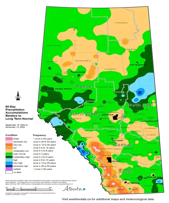
Map 6: Over the past 60 days, a large area along the foothills and adjacent plains, stretching from Rocky Mountain House south to the US border and out as far east as Coutts, has received below normal precipitation with several pockets approaching once in 25 to 50-year lows (Map 6). Elsewhere, in each of the four agricultural regions, many other areas are experiencing once in 3 to 6-year lows. However, there are also many areas that are near normal, and a large area across the North East Region, centered in Lac La Biche County, that is currently near once in 12 to 25-year highs.
Soil Moisture Reserves Relative to Normal
Map 7 & 8: Despite a series of dry years and two widespread severe droughts in 2021 and 2023, current soil moisture reserves (Map 7) are tending to near normal across approximately 65% of the province’s agricultural areas. Although it's important to note, that soil moisture responds relatively quickly at this time of year when precipitation is near to above average, particularly on those lands where soil moisture was well below average only a few months ago.
In early September, large parts of the North East, North West, Central, and Peace Regions had below normal soil moisture reserves (Map 8). Since that time, soil moisture has improved across the North East and through parts of the western part of the Peace Region (Map 7). In contrast, soil moisture reserves have declined across the western portions of the South Region and dry conditions have intensified through the western portions of the Central Region.
Perspective
Map 9 & 10: The cold season (October to March) is Alberta’s dry season (Map 9). In agricultural areas, this 6-month period only accounts for approximately 20% of the average annual precipitation across the southern portions of the province, increasing northward to the Peace Region where roughly 35% of the average annual moisture falls during this time. As a result, for the plains areas winter is typically a time of low moisture accumulation relative to the wetter months of the year (May, June, and July).
Winter has barely begun across Alberta, and there is still ample time to receive much needed precipitation. However, across the mountains that feed our rivers, dams, and reservoirs, winter is an important season for moisture accumulations with some areas likely exceeding 40% of annual moisture accumulations during the cold season. This year, ample snowpacks in the mountains will be needed to bring high elevation meltwater generated this spring to the parched water bodies so critical for our plains-based riparian areas and the agricultural activities that go on in the surrounding landscapes. Additionally, on the plains, often with the exception of southern Alberta, winter moisture is responsible for the spring freshet (runoff), which occurs when snow cover rapidly gives way to bare land bringing a mass delivery of water to the land that helps renew water levels in our various water bodies. Several dry years and a notable absence of wet years, stemming back to 2017 (Map 10), has left many of our water courses in need of a significant recharge event.
Contact Us
Saddle Hills
Junction of Hwy 49 & Secondary Hwy 725
RR1, Spirit River AB
T0H 3G0
T. 780-864-3760
Fax 780-864-3904
Toll-free 1-888-864-3760
frontdesk@saddlehills.ab.ca
Sign up to our Newsletter
Stay up to date on the Saddle Hills activities, events, programs and operations by subscribing to our eNewsletters.


