Moisture Update - June 19, 2024

Synopsis
Map 1: Since June 13, 2024, rainfall has been highly variable across the province (Map 1) and temperatures have continued to remain below normal, with many areas receiving overnight frosts between June 15 and June 20. Thankfully, last week much of the Peace Region received upwards of 40 mm of moisture, along with the northwestern parts of the Southern Region. In contrast, previously dry areas around Grande Prairie and the extreme northern portions of the Peace Region, only received between 5 to 10 mm and are still in need of meaningful moisture following several months of below normal precipitation. Elsewhere, dry areas are beginning to emerge through parts of the other agricultural regions, and many stations have recorded less than 5 mm over the past 7-days.
Cool weather and relatively young crops have likely helped stave off acute moisture stress in the drier areas to some extent, while at the same time having also limited evaporation and soil drying in the wetter areas. Unfortunately, since June 15, 2024, persistent and unseasonably cold weather has led to several overnight frosts that may have caused some localized damage to crops.
Frost - June 15 - 20, 2024
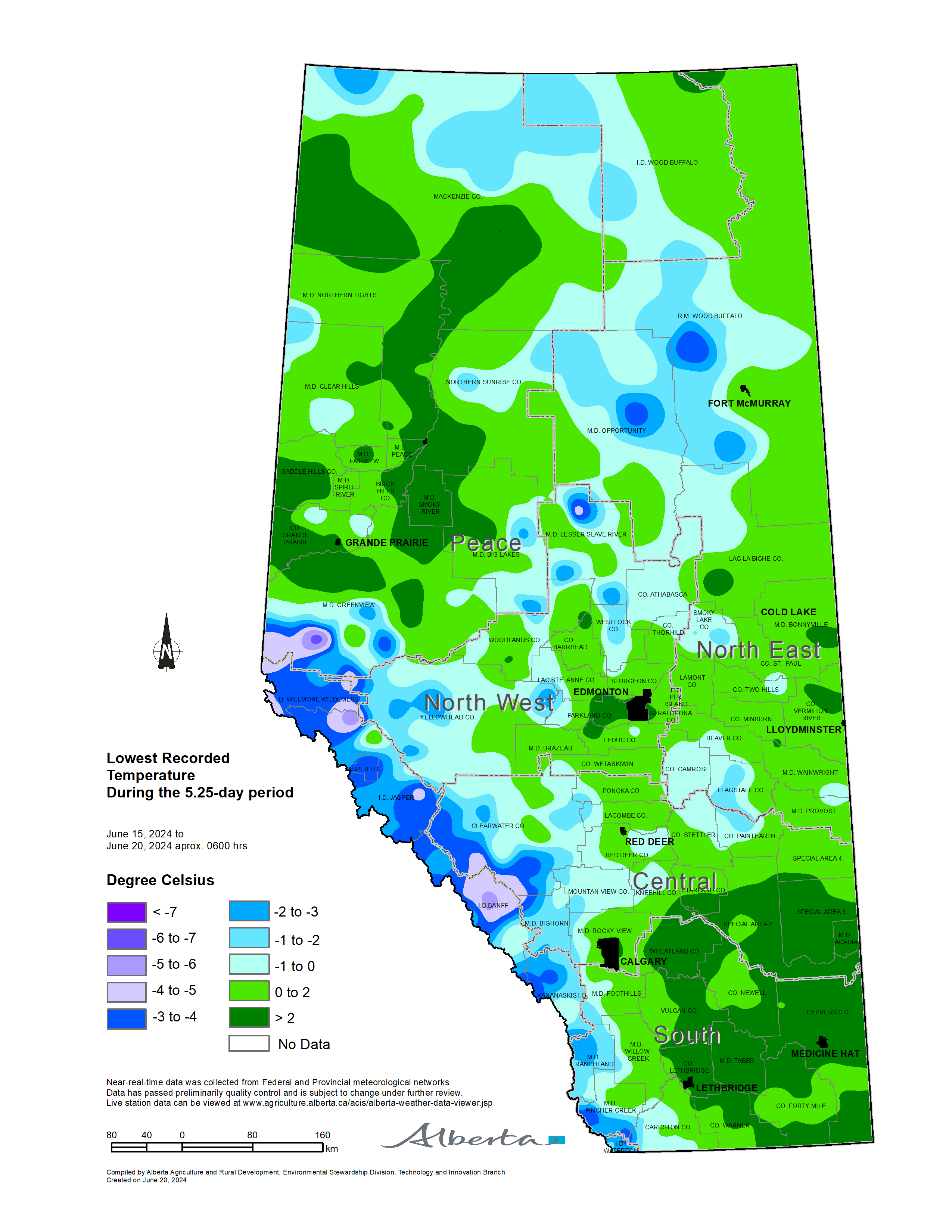
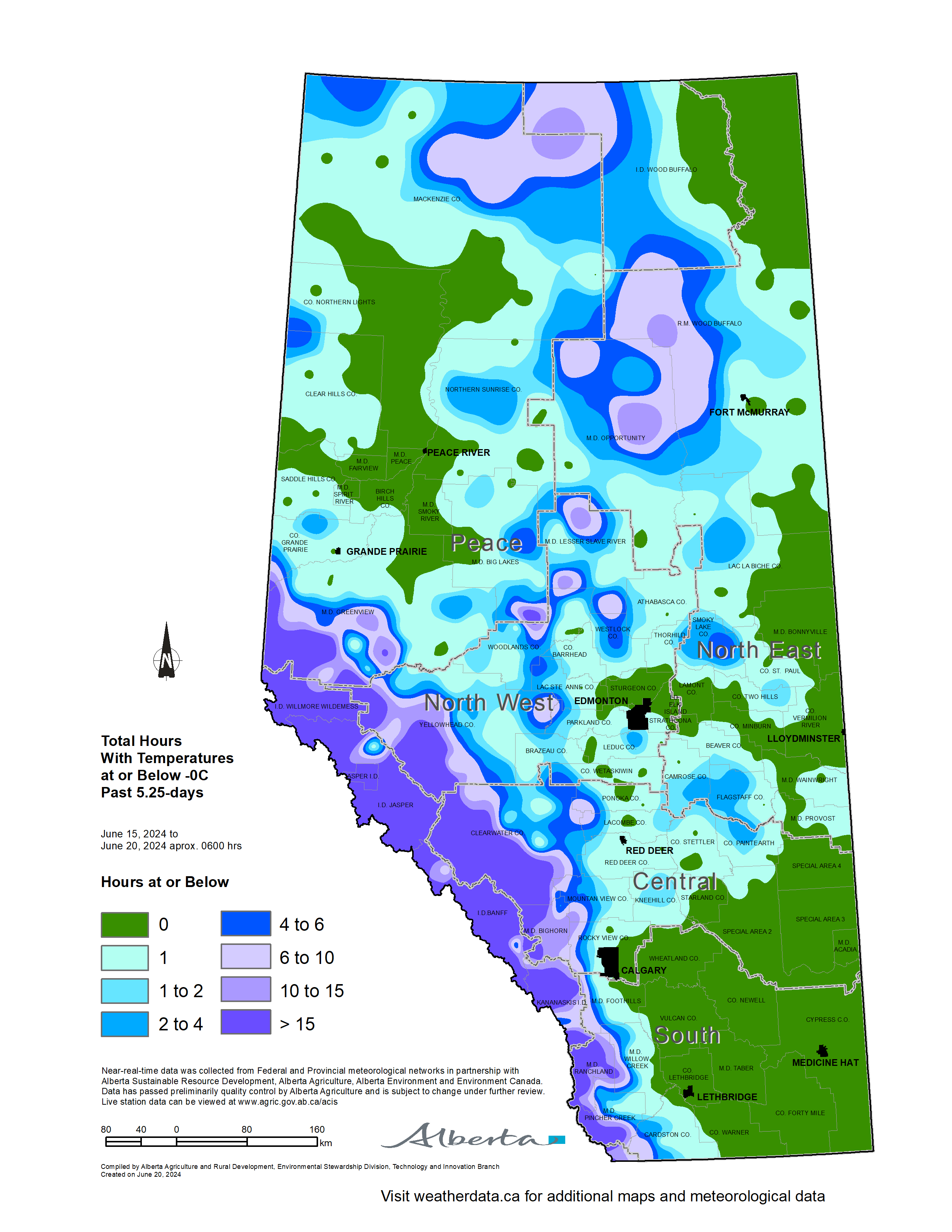
Maps 2 & 3: A mid-June frost appeared throughout a widely scattered area affecting each of the Agricultural areas, with temperatures dipping below the freezing mark (Map 2). Light coverings of snow on the ground were reported as far south as the Lethbridge area. Many lands saw frost appearing in the early morning over a several days, with total hours at below the zero mark indicated on Map 3. Please note that these are not consecutive hours but rather total hours over the 5-day period that were at or below the freezing mark. Locally, low lying lands and frost-prone areas may have seen colder temperatures for longer periods of time than are otherwise depicted on these maps.
Recent Precipitation Trends
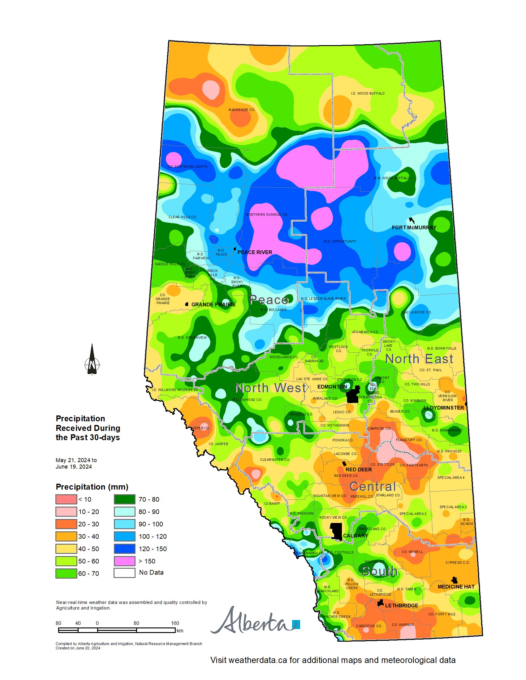
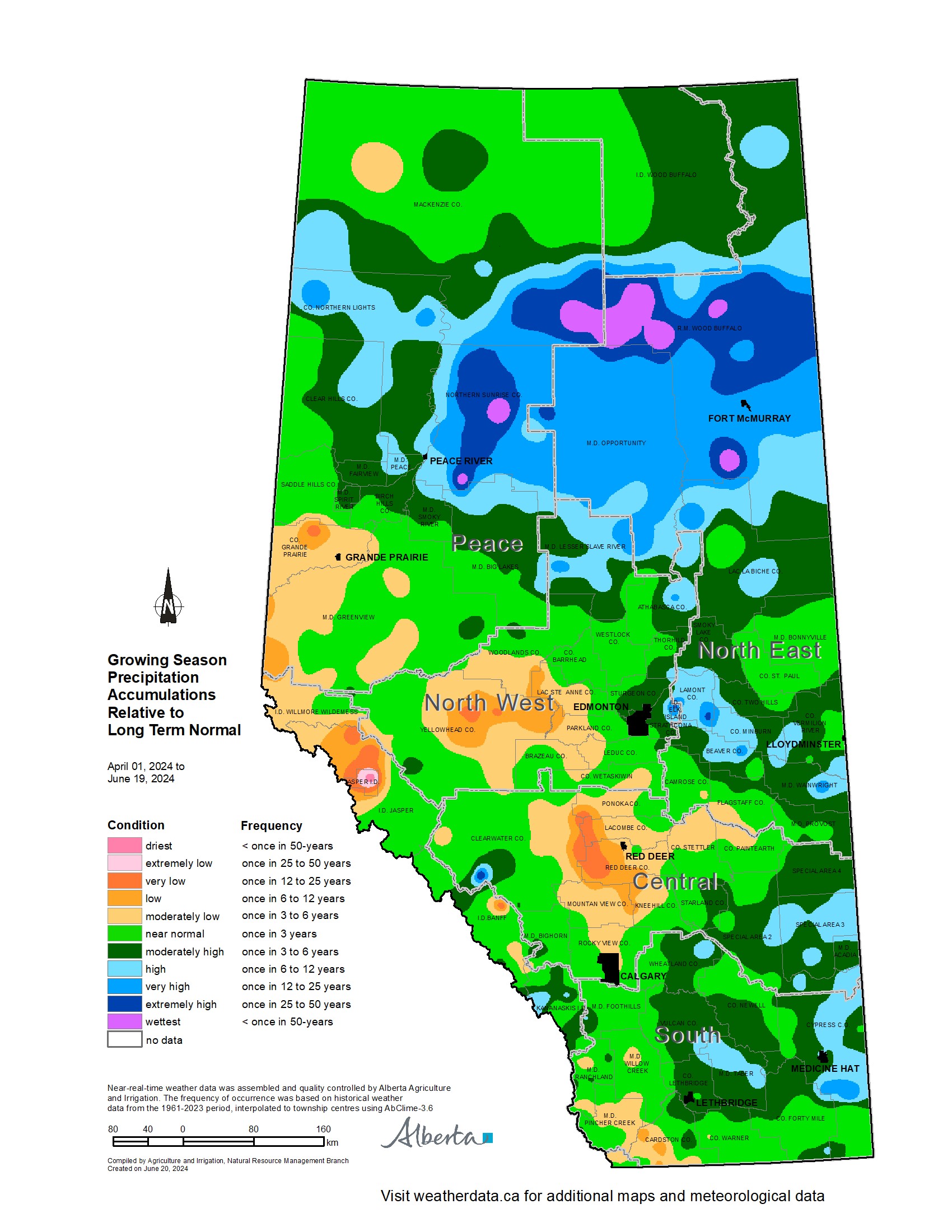
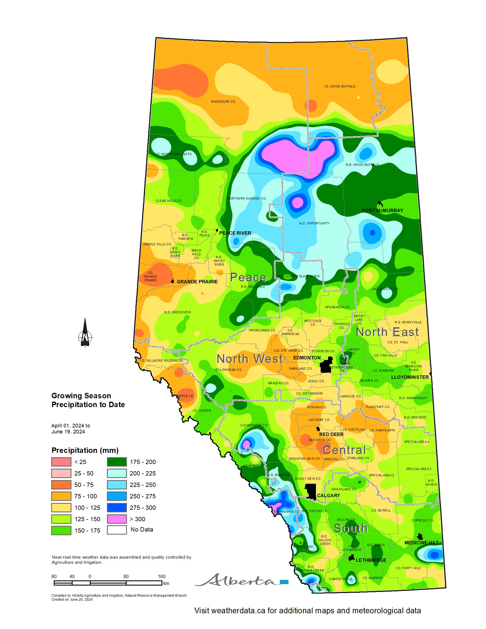
Maps 4, 5, 6, 7 & 8: Over the past 30-days, it has been relatively dry across many lands lying from Slave Lake in the north to the US border in the south (Map 4). Along the Milk River Ridge, relatively large areas are trending to once in 12 to 25 year lows. Similarly, there are a few dry pockets developing both south and east of the city of Red Deer. For those lands lying south of the Trans-Canada Highway, this may be significant as the typically wet month of June grades into a sudden drying trend that usually emerges in July. However, Mother Nature is full of surprises and the growing season is still far from over. Early season moisture and cool weather has likely helped reduce moisture stress across the drier areas, but may also be hampering field activities and crop growth in the wetter areas. Looking forward, near normal rains and adequate heat will be needed to sustain promising crops. Reports of lush, green hills across normally dry landscapes in the southern parts of the province, is fueling optimism.
Over the last 30-days, much of the Peace Region has received at least 80 mm of rain, with some lands receiving more than 150 mm (Map 5). Therefore, it seems in this area, drought conditions are currently being held at bay, following several months of dry weather and very disappointing snowpack development over the winter. Elsewhere, a dry area is emerging north-east of Red Deer, affecting parts of the counties of Camrose, Flagstaff, Steller, and Paintearth, where less than 20 mm has fallen since May 21, 2024.
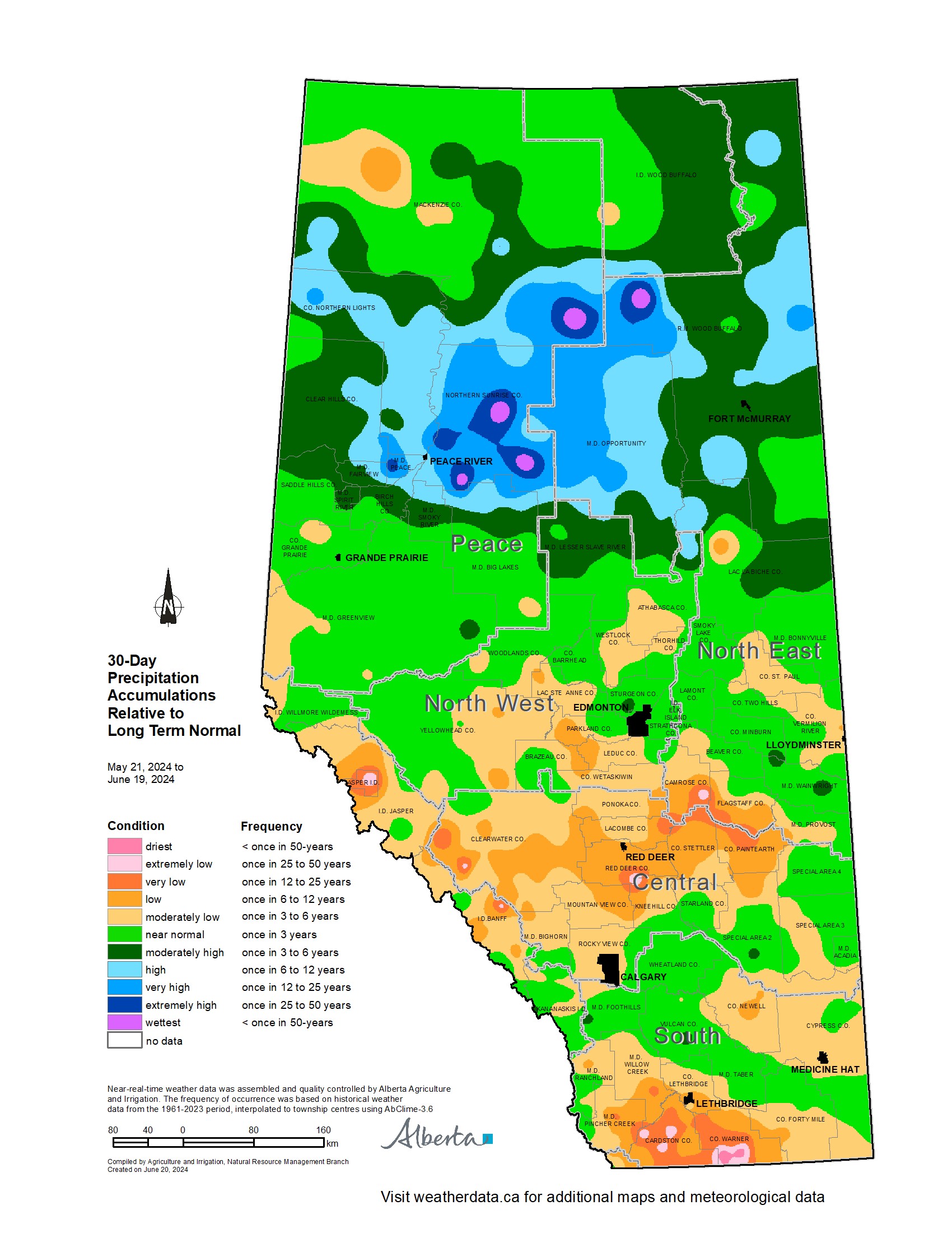
Since the start of the growing season on April 1, 2024, most of the province has received at least near normal moisture, with notable exceptions in each of the four Agricultural Regions (Map 6). Grande Prairie and the surrounding lands to the west, are quite dry and La Glace AGCM has only recorded 55 mm since the beginning of April (Map 7) compared to the average of 105 mm. Similarly, a relatively large pocket in the North West has received less than 100 mm, with only 82 mm being recorded at Evansburg compared to the average of 150 mm. Around Red Deer, two small pockets received less than 75 mm, with only 66 mm recorded at Dickson Dam relative to the 150 mm which is normal. However, unlike southern Alberta, July and August in these areas tends to be relatively wet (Map 8) and there is still time to see adequate moisture ahead of the fall harvest.
Perspective
Mid-June frosts are relatively rare events, particularly if only looking back as far as the mid 20th century. Today there are more than 500 weather stations across Alberta, that report hourly information. Defining the occurrence, extent, and severity of frost, or, for that matter, any unusual weather events is much easier than it was in the past. In fact, you need to go back to the early part of the 20th century, to readily find similar examples of mid-June frosts that were apparently quite common over a three decade period from 1900-1930. This coincidentally occurred during Alberta’s driest and most extreme period in our meteorological record. For example, in the Edmonton area between 1901 and 1931, there were six years were temperatures dropped below 0, between June 13 and June 20. These years were 1902, 1910, 1920, 1924, 1926 and 1931. For comparison, in 1902 there were only 17 stations operating in the province and by 1930 there were only 101 stations. None of these stations recorded hourly information. Coincidentally, during this last frost event, the Edmonton area did not dip below freezing, with the coldest hourly temperatures hovering around +2. This was likely, at least in part, due to the urban heat island effect moderating overnight lows.
Contact Us
Saddle Hills
Junction of Hwy 49 & Secondary Hwy 725
RR1, Spirit River AB
T0H 3G0
T. 780-864-3760
Fax 780-864-3904
Toll-free 1-888-864-3760
frontdesk@saddlehills.ab.ca
Sign up to our Newsletter
Stay up to date on the Saddle Hills activities, events, programs and operations by subscribing to our eNewsletters.