Moisture Update - July 24, 2024
Synopsis
Maps 1-7: Since July 18, 2024, above average temperatures have prevailed, alongside little relief in the form of rain. Since the heat first arrived on July 7, approximately 3-weeks ago, many locals have seen approximately 10 days that exceeded 30°C. Across the southeast portions of the province, several stations recorded temperatures of nearly 40.0°C (Map 1). This was still far from the all-time heat record in Alberta, where temperatures reached 43.3°C, on July 21, 1931, at Bassano Dam. During the last three weeks, most of the agricultural areas saw maximum temperatures reach as high as 34 to 36°C. Looking back as far as 1961, over the past 15-days, temperatures this warm are seen on average less than once in 50-years (Map 2). Unfortunately the meteorological record prior to 1961 is too sparse for generating maps of this kind, which would allow for a more meaningful, long-term perspective on the recent heat wave.
Unusually high temperatures throughout last week, were accompanied by sporadic thunderstorm activity across the western portions of the province, as well as through the Peace Region, and parts of the Southern Region (Map 3). Unfortunately, rainfall was largely absent across much of the east-half of the province. Late on June 24, 2024, and early into the morning of July 25, 2024, a moisture bearing low pressure system moved into the province from the west, bringing meaningful rainfall to many parts of the North West, Peace, and western portions of the Central Regions. Map 4, which depicts unverified raw data, adds the rain that’s fallen during the 7-day period depicted in Map 3, and is promising for much of the Peace and North West Regions, with many locations now exceeding 20 mm. This system is forecast to persist until at least Sunday, with an additional 10-60 mm expected to fall across a large area of the province, beginning north of Red Deer, by midnight on July 25, 2024 (Map 5). As the system moves eastward, more rain is expected to fall in this general area by Friday (Map 6). On Sunday, a second low is expected to form, bringing some moderate relief to some lands, even potentially as far south as Brooks (Map 7).


30-Day Precipitation Trends
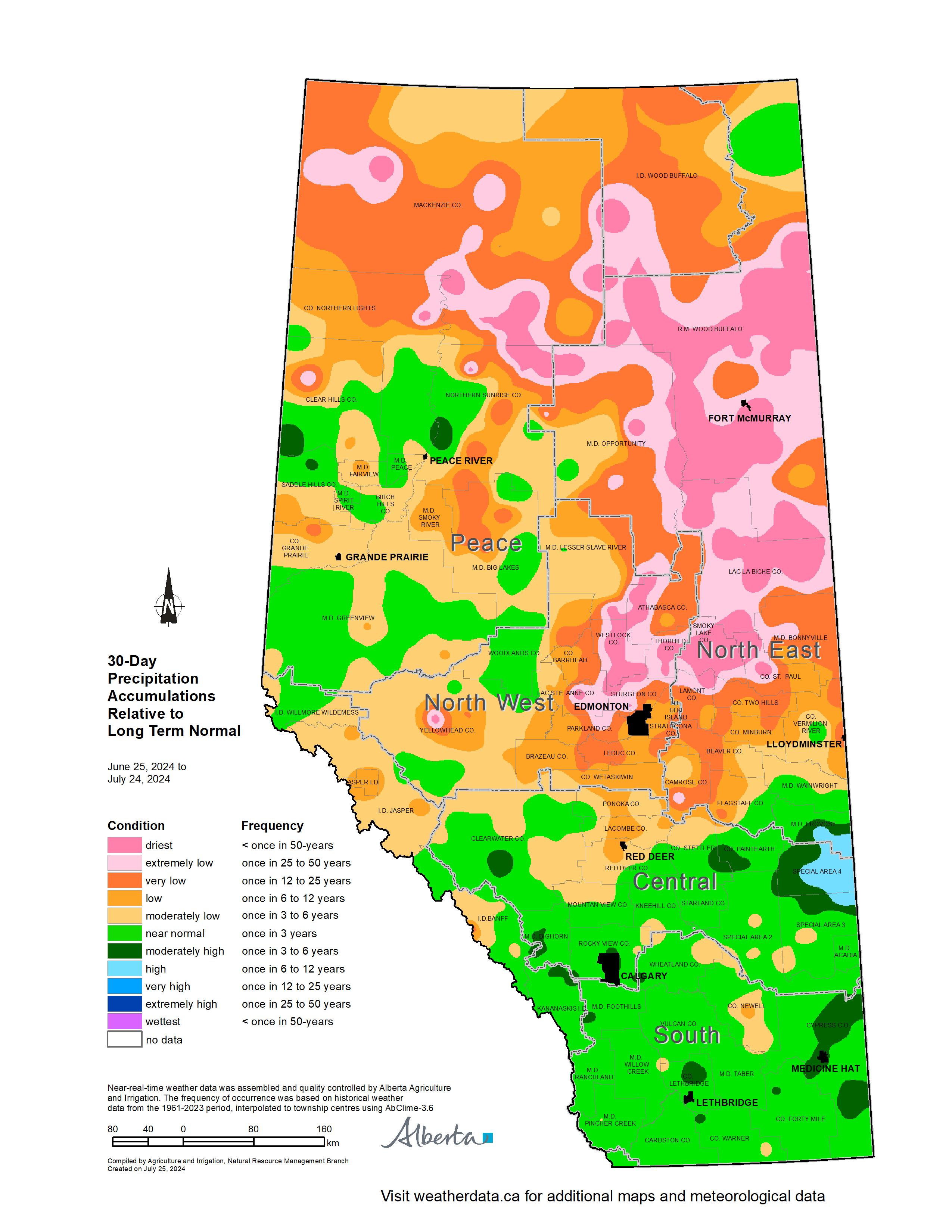
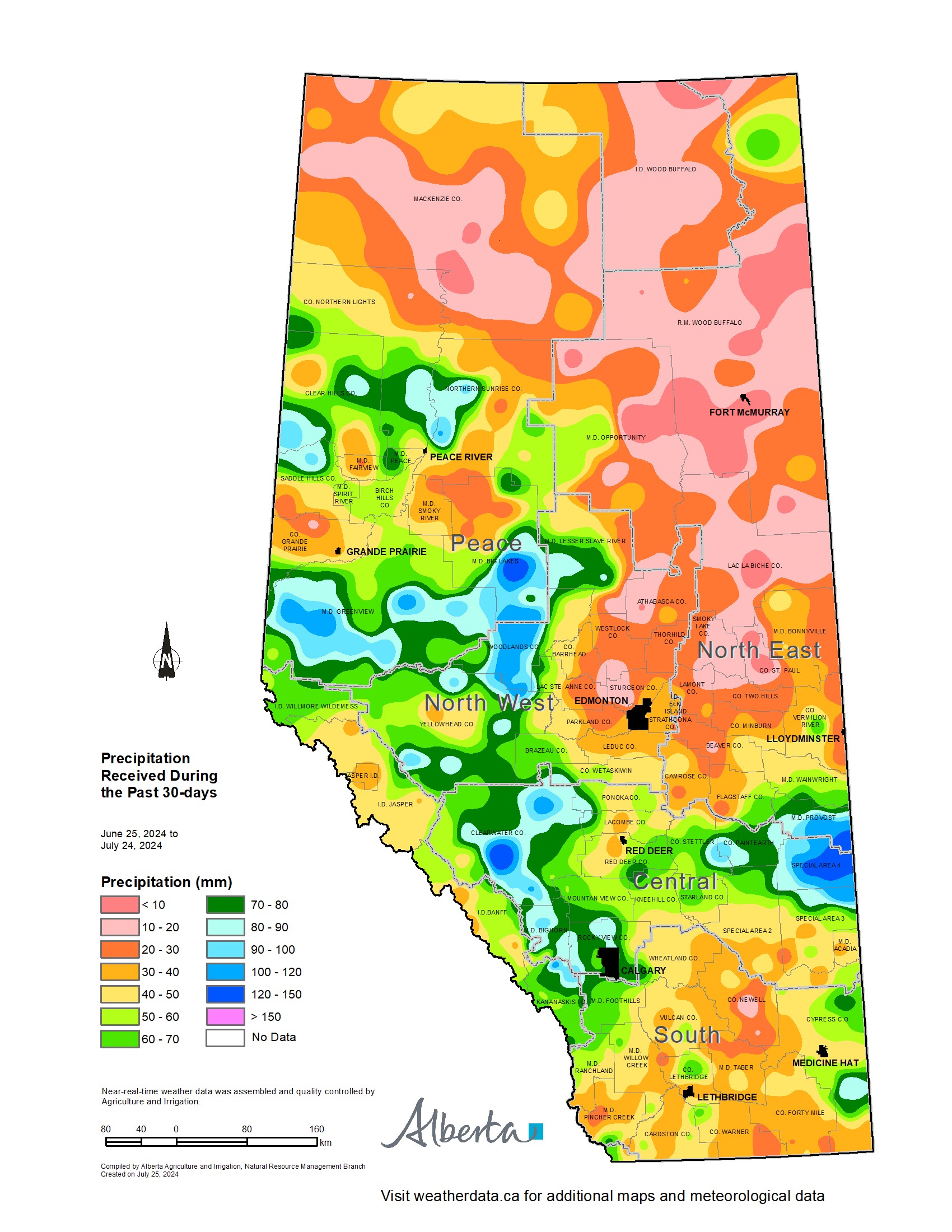
Maps 8 & 9: Over the past 30-days, most of the southern portions of the province, lying generally south of Red Deer, have seen at least near normal precipitation accumulations (Map 8). However, July is normally a dry month through much of the Southern Region, so total precipitation accumulations during this heat wave are still less than 40 mm through many locales (Map 9). Despite this, there are still several areas that have received reasonable moisture, with many stations recording well over 60 mm through broad swaths of the Central Region, along with parts of the Northwest, and the extreme southern and central Peace Region. In contrast, large parts of the North East, eastern portions of the North West, and parts of the extreme northern Peace Region, have been experiencing near once in 50-year low precipitation accumulations (Map 8), with a relatively large area receiving less than 30 mm (Map 9). Fortunately, a major cool down is occurring and these areas are likely to see ample rain over the next few days (Maps 5-7). For those crops that have not been excessively damaged by heat and/or moisture stress, this rain will be beneficial, at least in the short term. Further rains will still likely be needed over the coming weeks, to ensure present yield potential is sustained.
Soil Moisture Reserves Relative to Normal
Current soil moisture reserves are highly variable, ranging from at least near normal across parts of the Southern Region and Special Areas, as well as through the Central Peace Region, to once in 50-year lows through parts of the Peace, North West, North East, and Central Regions. These areas need rain now and, thankfully, at least for those areas lying north of Red Deer, it appears to be on the way. The cooling trend over the next several days will help further reduce moisture stress in crops, particularly if the rain falls as it is forecast to do.
Perspective
The effects of recent heat and lack of rainfall have likely not yet been fully quantified. Last week’s Crop Report, which was current as of July 16, was released only 9-days into the current heat wave. In this report, it was stated that, “While conditions are still rated above the 5- and 10-year average provincially, crops are starting to show signs of heat stress, like heat blast in canola, while other crops are coming out of flowering prematurely or dropping tillers.” At this time, provincially 72.9% of 'major crops' were rated good to excellent, which is above the 10-year average of 63.2%. Tame hay ratings were marginally better than the 10-year average in the good to excellent categories. This week’s Crop Report will be released on Friday, July 26, 2024, current as of July 23, and it is likely that these values will be lower. Later in the season, a first look at estimated yield potentials will shed further insights into the potential yield declines that may have occurred with July’s persistent hot and dry spell.
Contact Us
Saddle Hills
Junction of Hwy 49 & Secondary Hwy 725
RR1, Spirit River AB
T0H 3G0
T. 780-864-3760
Fax 780-864-3904
Toll-free 1-888-864-3760
frontdesk@saddlehills.ab.ca
Sign up to our Newsletter
Stay up to date on the Saddle Hills activities, events, programs and operations by subscribing to our eNewsletters.


