Moisture Update - July 17, 2024
Synopsis
Maps 1, 2, 3, 4 & 5: Precipitation has been quite hit and miss since July11, 2024, ranging from a few areas in the North East Region that received upwards of 20 mm, to large areas in each of the four agricultural regions that received no rain (Map 1). Since the end of the first week in June, temperatures have been above average for this time of year, and highs of 30°C or more have been common. This has come alongside many warm nights where temperatures failed to dip below 20°C. Hot weather is expected to persist this weekend and well into next week, which will continue to put many crops under stress, particularly in those areas that have low soil moisture reserves and/or have remained dry over the past few weeks. Long range weather predictions are pointing to a cooling trend towards the end of next week, as a low pressure system is set to arrive from the west. Hopefully this will bring much needed moisture to the province, in the face of this persistent heat wave.

Recent Precipitation Trends
Maps 6, 7 & 8: Growing season precipitation accumulations have been variable, with about half of our agricultural lands receiving at least near normal precipitation since April 1, and about 25% of these lands receiving less than 70% of average (Map 2). Unfortunately, this time frame tends to be 'back-loaded' with the majority of this precipitation occurring prior to the onset of July, and as such it does not provide a completely accurate depiction of current moisture conditions across the province.
Following a dry winter, in April most lands south of Red Deer received at least near normal moisture (Map 3), while parts of the southern Peace Region along with a large areas east of Red Deer were dry, along with a few pockets in the North West and North East Regions. May was a relatively wet month, with much of the east-half of the province receiving well above average moisture, with a few small dry pockets remaining west of Edmonton and West of Red Deer (Map 4). June, on average one of the wettest months of the year, saw a drying trend emerge across parts of the North East, through much of the North West, and most of the west-half of the Central Region, along with large areas of the Southern Region (Map 5). As July unfolded, hot weather began to build into the province, with most areas experiencing well below normal moisture since July 1 (Map 6). This is with the exception of a few areas in the Southern Region, the Central Peace Region, and the borderlands between Alberta and Saskatchewan, as far north as Lloydminster. Moisture deficits seen across the North West and western portions of the Central Regions, and northern parts of the North East Region, intensified, with some areas experiencing once in 50-year lows.
Looking out over the past 60-days, from May 19 to July 17, moisture deficits have enveloped most of the North West Region, parts of the North East Region, the west-half of the Central Region, much of the Southern Region (Map 7), along with the southern and northern portions of the Peace Region. Currently, many crops are in critical stages of development, and heat and lack of moisture are affecting yield potential. July is a very critical month for crops, and most are well developed with moisture demand entering peak levels, rendering crops very susceptible to moisture stress. According to the current weather forecasts, we still have several days of heat to endure. Hopefully the low pressure system that is currently off the coast of B.C. is able to penetrate the interior, and bring with it a much needed cool down late next week, along with some widespread rains.
Perspective
The cooler weather predicted to arrive late next week, is still several days off, and while the forecast models tend to agree, it still remains to be seen if this will materialize and bring much needed moisture. The 2024 growing season has proven to be quite variable so far, with unseasonably cool temperatures persisting through June, and in many areas, wet weather dominating through April, May, and early June, that suddenly turned into a widespread drying trend in recent weeks. Hopefully this pattern breaks soon, and towards the end of July and well into August, we see temperatures moderate, along with a return to more normal precipitation patterns.
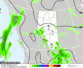
Current 12 hour precipitation forecasts for today, courtesy of Alberta Forestry and Parks Fire Weather Section (Map 8), Friday (Map 9), and Saturday and Sunday (Map 10), indicate that most of the moisture we expect to receive over the next few days will be concentrated along Alberta’s western border.
Contact Us
Saddle Hills
Junction of Hwy 49 & Secondary Hwy 725
RR1, Spirit River AB
T0H 3G0
T. 780-864-3760
Fax 780-864-3904
Toll-free 1-888-864-3760
frontdesk@saddlehills.ab.ca
Sign up to our Newsletter
Stay up to date on the Saddle Hills activities, events, programs and operations by subscribing to our eNewsletters.


