Moisture Update - December 11, 2024
Synopsis
Maps 1 & 2: So far this winter, from November 1 to December 11, approximately 60% of the province has received at least average precipitation accumulations, relative to the 1961-2023 period (Map 1). Much of the east-half of the province has received well above average moisture, ranging to over 200% of average across parts of the North East Region and through parts of the southern Peace Region. In contrast, conditions have remained drier than average across the western portions of the province affecting the North West, Central, and South Regions, along with parts of the northern Peace Region. Despite some spells of warm weather and partial melting of accumulated snows, most of the agricultural areas currently have near normal snowpacks for this time of year (Map 2). Along the east-half of the province, between Cold Lake and the US border, many areas experience snow packs this deep on average less than once in 6 to 12 years. Similarly, snowpacks across the extreme southern portions of the Peace Region have exceeded once in 3-to-6-year highs, in some locations. However, snowpacks are still below normal across the extreme southern portions of the South Region and along the western portions of the Central Region.
It’s still very early in the winter season but for most agricultural lands, this marks a promising start towards building healthy and much needed snowpacks ahead of this year’s spring melt. Hopefully, we can remain in this general pattern over the next several months and that the wet trend also begins to extend to those areas that are still in a dry pattern.
90-Day Precipitation Trends
Maps 4 & 5: Over the past 90-days, a large strip of land running along the foothills between Edson and the US border, has remained relatively dry, with the driest areas located west of Red Deer (Map 3). Across this large area, several isolated locations have seen less than 50% of average precipitation, including lands in and around Sundre. Several locations scattered through the southwestern portions of the South Region, have received less than 40 mm of moisture (Map 4). Farther west across the mountains, conditions have been much wetter, with several high elevation stations recording over 160 mm of precipitation. Currently, two mountain stations have recorded more than 300 mm of precipitation over the last 90 days, Three Isle Lake (324 mm), in the Kananaskis region and Gardiner Head Waters (312 mm), located near the continental divide south west of Pincher Creek. Across the eastern-third of the province, stretching up from the US border, nearly as far north as Fort McMurray, several stations have recorded more than 130% of average precipitation, with some isolated areas exceeding 200% of average (Map 4). Similarly, much of the south-half of the Peace Region has received above average precipitation, particularly across the southwest, which is a welcome trend given the previously dry conditions that have persisted for several months prior to this.

365-Day Precipitation Trends
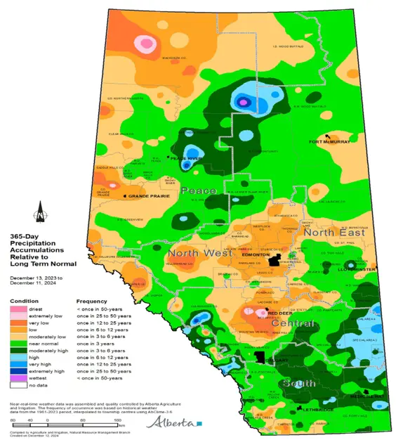
Map 5: Year-over-year, conditions are quite variable, with large precipitation deficits persisting across much of the North West Region, western portions of the Central Region, and through much of the western half of the Peace Region (Map 5). Additionally, a relatively large portion of the southwestern corner of the South Region is still very dry. Currently, the driest areas are experiencing at least once in 25-year lows (year-over-year) and these are located north of Fort Vermillion, in and around Red Deer, and just northwest of Grande Prairie.
Perspective
Maps 6, 7 & 8: Winter (November to March) is a relatively dry season in Alberta (Map 6), and, as such, even above-average moisture over this time frame is typically not enough to make a significant impact on “year-to-date” moisture deficits. For example, across the Central Region, just over 15% of the average annual moisture falls during the winter (Map 7) and for most of the province lying south of Olds, much of this is lost to evaporation/sublimation during warm and/or windy spells. However, across the Peace Region, winter moisture tends to be very important for the annual water cycle as it is retained on the land until spring and released rather suddenly as the weather warms. Many locations in this area rely on deep snows to renew the land in the spring, and at least 25% of their annual moisture falls during this time frame. For agriculture, May, June, and July remain the most important months for receiving precipitation, with more than 50% of the annual moisture falling through the Central Region and at least 40% of it falling across most of the Peace Region (Map 8).
Next year’s cropping season is still months away and there is ample time to receive moisture. As always, at this time of year, we can only be patient and hope that sufficient moisture comes in a timely fashion for next year’s growing season.
Contact Us
Saddle Hills
Junction of Hwy 49 & Secondary Hwy 725
RR1, Spirit River AB
T0H 3G0
T. 780-864-3760
Fax 780-864-3904
Toll-free 1-888-864-3760
frontdesk@saddlehills.ab.ca
Sign up to our Newsletter
Stay up to date on the Saddle Hills activities, events, programs and operations by subscribing to our eNewsletters.


