Moisture Update - December 11, 2023

Synopsis
Winter threatened to come early in late October, with a sudden drop in temperatures that was accompanied by early snow fall across parts of the Peace Region and through many areas lying between the Yellowhead Highway and the US border. However this turned out to be a short lived and November arrived warm and dry across most of the province.
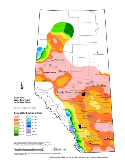
By mid-November, snowpacks had melted off as far north as the Peace Region. Since mid-November some areas have seen modest moisture, but as of December 11, 2023, many areas across each of the four agricultural regions are still virtually snow-free
Winter Precipitation Accumulations: November 1 to December 11, 2023
Since November 1st, the unofficial start to winter in Alberta, precipitation has been well below average across most areas (Map 2), ranging from once in 3 to 6-year lows throughout most of Southern Alberta, to once in 50-year lows through large parts of the North East and North West Regions, along with much of the Southern Peace Region and a relatively small area lying northeast of Brooks. Total accumulations in the agricultural areas are greatest along the foothills and through parts of the northern-half of the Peace Region, generally in the 10 to 20 mm range (Map 3). This falls off quickly in other areas with 5 to 10 mm common through much of the Central and Peace Regions. Notably, much of the North West and parts of the Northeast Regions have received less than 3 mm since the start of winter.
Long Term Precipitation Trends as of December 11, 2023
Over the past 90-days, much of southern Alberta has been trending to near normal (Map 4), which is at the very least a hopeful trend as this is normally a dry time of year. This has helped, somewhat, to bring modest amounts of moisture to a very parched landscape with most parts of the Southern Region receiving 40 to 80 mm of moisture (Map 5). Unfortunately apart from Southern Alberta, most of the rest of the province has continued to be dry with precipitation accumulations ranging from once in 3 to 6 year lows across most of the Central Region to less than once in 25-year lows across large parts of the North West, North East and Peace Regions. For much of the east-half of the Central Region, precipitation accumulations have been well below 30 mm.
Moving northward conditions have been drier still through the North East, North West and Peace Regions with many lands receiving less than 20 mm over the past 90-days. For much of the North West, this may be less of a concern as the overall balance of moisture since Mid-June (180-days) has been above normal (Map 6). However most of this fell as heavy rains in June and stubbornly dry weather patterns have been dominating since at least late August.
Perspective
An unusually warm and dry November left many worried about the prospects for the rest of the winter and some wondered if this was indeed “unprecedented”. One thing the meteorological record teaches us is, that the weather over the next few hours, weeks or months is often not a good predictor of the weather coming in the next few hours, weeks or months. The old adage does indeed have some truth: if you don’t like the weather in Alberta, wait 10 minutes. Many times in the past we have examples of abrupt trend reversals between wet and dry and/or warm and cold spells. Winter is still far from over and there is ample time to get further moisture and unfortunately bitterly cold winter temperatures.
Looking back through 123-years of Edmonton’s Meteorological Record (1901-2023), we see that there were at least 17-years that there was no snow cover on November 30th. In the 22-year period alone, from 1907 and 1928 there were at least 6-years where there was no snow on the ground at the end of November, and four of these years had average temperatures for the month that were warmer than November 2023. In comparison, in the last 21 years there has only been 4-years with no snow on the ground on November 30th (2002, 2004, 2008 and 2023) and none were as warm as 2023. Maximum winter snow water equivalents (water in the snowpack at maximum snow cover) for the 1991-2020 period average out to approximately 85 mm. In comparison maximum snow water in the 2002-2003 winter snow packs reached 120 mm, and for 2004-2005 (34 mm) and for 2008-2009 (81 mm). So one was above average, one was below average, and one was near average. For now, we must wait and see what the winter brings. Many parts of Alberta are now long overdue a wet cycle. This is particularly true for the Southern and Central Regions.
Contact Us
Saddle Hills
Junction of Hwy 49 & Secondary Hwy 725
RR1, Spirit River AB
T0H 3G0
T. 780-864-3760
Fax 780-864-3904
Toll-free 1-888-864-3760
frontdesk@saddlehills.ab.ca
Sign up to our Newsletter
Stay up to date on the Saddle Hills activities, events, programs and operations by subscribing to our eNewsletters.


