Moisture Update - April 25, 2024

Synopsis
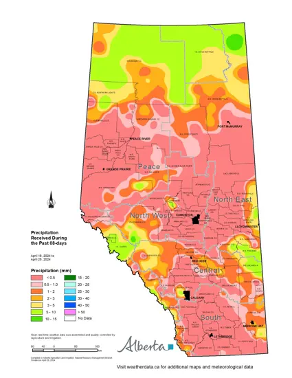
Map 1: Since April 17, 2024, it has been relatively warm and dry with precipitation levels ranging from 0 mm in most areas, to just over 10 mm across the far northern parts of the province (Map 1). Exceptions do exist along the extreme eastern portions of the province’s agricultural areas, with the most moisture of 5-10 mm, falling through parts of the Special Areas, and less than 5 mm falling elsewhere in this zone. This moisture was welcome given the lack of snowmelt runoff, but this is still not enough to reverse the long standing drying trend and meaningful moisture is needed immediately in the weeks ahead.
Over the next several days, conditions are expected to turn cooler and with this comes the promise of precipitation. Looking into next week, various forecast models all indicate a cool down, with conditions that are favorable for moisture, particularly across the southern Peace Region down through most of the Central Region. It’s still too early to tell where, and if, this moisture will fall, although this certainly means that hot dry weather is unlikely and that some areas will likely see much needed rain.
60-Day Precipitation Trends
Maps 2 & 3: Over the past 60-days most lands across the province that lie south of Red Deer, have been trending from near to well above normal for precipitation accumulations for this time of year (Map 2). Some lands north of Lethbridge see the last 60-day period, this wet on average less than once in 6 to 12 years. Maximum recorded precipitation amounts in these 'wet' areas range from 50 to 60 mm (Map 3), which has been enough to help improve soil moisture reserves, although more will be needed. Surface water supplies are critically low in many areas due to several years of persistent drought.
Most lands across the agricultural areas lying north and east of Red Deer, are still critically dry. Many parts of the central Peace Region and the border lands between the North West and North East Regions are trending to one in 50 year lows. These dry conditions have been exacerbated by below normal snowpack accumulations along with an early melt. Many areas did not see appreciable filling of surface water supplies (rivers, lakes dugouts) and unusually wet weather will be needed to fill them.
Soil Moisture Reserves
Maps 4 & 5: Soil moisture reserves are currently well below normal throughout most of the agricultural areas, with the exception of the Southern Region and the extreme southern Peace Region (Map 4). However, it should be noted that on this map, the definition of 'normal' lies between a one in three year dry and a one in three year wet. Therefore, it is likely many of the 'normal' areas on this map are still below the statistical average and are, in fact, on the dry side of 'normal'. Areas of one in 50-year lows are currently emerging across parts of the Peace and North East Regions.
Soil moisture levels historically increase rapidly in the spring with this trend persisting well into June, meaning if precipitation remains below average these areas are likely to expand rapidly.
Soil moisture reserves relative to normal are down approximately 50 mm or more across most of the agricultural areas, with the exception of the Southern Region (Map 5). A wet period that delivers 50 to 75 mm of precipitation is much needed. If this came over a few days, it would likely be enough to build reserves to near normal and help plants through short duration dry spells in the near term. Pasture lands weakened by last year’s drought are beginning to break dormancy and need moisture soon to minimize further declines in yield potential.
Perspective
Simply put, precipitation, be it rain or snow, is desperately needed across most of the province. Thankfully the wet season lies ahead and there is still time for precipitation ahead of spring. This situation is familiar, as we have experienced many times in recent years, where a dry start to the season has brought the ever-present fear that it will remain so. Last weeks weather, or even that of last month or last year, is not a good predictor of the weather next week, next month, or next year. Local forecasts are generally reliable only for a few days and nobody knows for sure what May will bring, let alone June and July. For now all we can do is watch the skies and hope the moisture comes soon. At the time of writing the moisture for next week remains favourable.
Contact Us
Saddle Hills
Junction of Hwy 49 & Secondary Hwy 725
RR1, Spirit River AB
T0H 3G0
T. 780-864-3760
Fax 780-864-3904
Toll-free 1-888-864-3760
frontdesk@saddlehills.ab.ca
Sign up to our Newsletter
Stay up to date on the Saddle Hills activities, events, programs and operations by subscribing to our eNewsletters.


