Moisture Update - April 17, 2024

Synopsis
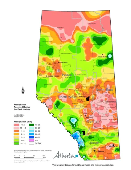
Map 1: Since April 7, 2024, further moisture has fallen across much of the province (Map 1), but unfortunately not everywhere. Moisture is still desperately needed across much of the North East and Central Peace Regions, and through parts of the North West Region.
Over the past 10 days, parts of southern Alberta received an additional 10-15 mm of moisture while some areas in the mountains and foothills saw upwards of 30 mm. Notably many of the northern forested areas received 5 to 15 mm, but coverage was sporadic and not all areas received moisture.
For those areas north of the TransCanada Highway, April is still on average a dry month with the wet season arriving later the further north you go. For the Peace Region, the May long weekend usually marks the start of wetter weather in a 'normal' year.
Recent Precipitation Trends
Maps 2 & 3: Over the past 30-days, most land in the province south of Red Deer, has been trending from near-normal to above-normal for precipitation accumulations for this time of year (Map 2). In fact, some land north of Lethbridge, sees this 30-day period this wet on average less than once in 50-years. However, this is typically a dry time of year, so this alone is not enough to reverse long standing precipitation deficits. Maximum recorded amounts in these 'wet' areas range from 50 to 60 mm (Map 3), which may be enough to curtail field operations in the immediate future. Some producers will be hoping for a short, warm, dry spell so that they are able to begin seeding ahead of May rains, should they be plentiful this year.
Significantly, most of the North East and Peace Regions are still in a dry pattern, which has persisted since the fall. These areas had very little snow coverage this spring and emerged dry from winter. Snow melt runoff is a very important source of surface water for streams, lakes, rivers, dugouts, and wetlands, and this simply did not occur. In the absence of early rains, pastures, winter wheat, and native vegetation rely on moisture from snow melt as they break dormancy. Moisture is very much needed in these areas soon, although ample rains in May and June result in wide spread runoff and swell rivers, so there is still time to see surface water supplies rebound if the late spring and early summer rains begin as normal.
180-Day Precipitation Accumulations
Maps 4 & 5: Looking back over the past 180-days, most of southern Alberta and the western portions of the Central Region have been experiencing at least near-normal moisture, with some localized areas approaching once in 6 to 12 year highs (Map 4). In sharp contrast, large parts of the northern-half of the province are facing at least once in 50 year lows. Many of these lands have seen less than 40 mm over the past 6 months (Map 5).
Perspective
Maps 6 & 7: While we have seen a marked turn around in moisture conditions across the southern parts of the province, the north remains very dry. However, it is important to remember that in 2023, large parts of the North West Region and the extreme southern portions of the Peace Region, with a sliver of the North East Region, received ample moisture throughout the growing season, (Map 6). Many of these areas received more than 400 mm through June, July, and August (Map 7). This has likely had some carryover which is not reflected in Maps 1 to 5. What this carryover effect will mean this spring, remains to be seen.
Looking back over the past 12-years, most of southern Alberta has been in a relatively dry state since at least 2017, with a small area north of Lethbridge which has been dry since 2013. Furthermore, it’s worth noting that there have been no abundantly wet years across the south, with 2014 and 2016 showing as perhaps the last moderately wet years. Provincewide, 2016 was the last wide spread wet year. With several years of dry conditions prevailing across many areas, we are now long overdue a wet cycle. Wet years are very important for replenishing deep moisture reserves and critical for keeping the land more resilient to drought.
Head over the Climate and Atlas Maps hosted on the Alberta Climate Information Service, where you will find a complete series of historical moisture maps, dating back to 1901. Select the Precipitation folder and navigate to Historical Summaries 1901 to Current. Here you will find that that the first-half of the 20th century was arguably drier that what we have been experiencing over the past two decades. The period from the 1950’s to the late 1990’s appears to have been unusually wet and may have coloured our perceptions as to what 'normal' means for Alberta.
Contact Us
Saddle Hills
Junction of Hwy 49 & Secondary Hwy 725
RR1, Spirit River AB
T0H 3G0
T. 780-864-3760
Fax 780-864-3904
Toll-free 1-888-864-3760
frontdesk@saddlehills.ab.ca
Sign up to our Newsletter
Stay up to date on the Saddle Hills activities, events, programs and operations by subscribing to our eNewsletters.


