Moisture Update - May 20, 2024

Synopsis
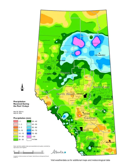
Map 1: Since the last report, Alberta was subjected to another widespread precipitation event. This time, the moisture was concentrated in the north, with a large area in and around Fort McMurray receiving well over 40 mm of rain (Map 1). The highest amounts were recorded at the Piccadilly Auto Station at 138.6 mm and Britch Mountain Auto at 118.2mm, both located northwest of Fort McMurray. Additionally most, but not all, of the Peace Region received its first meaningful moisture in months, with totals ranging from 20 to 50 mm. However, the western portions of the Peace Region still have some dry areas, with several stations recording less than 15 mm in recent days.
Elsewhere the North East Region and eastern portions of the Central Region, received upwards of 20-30 mm, ranging as low as 10-15 mm in a few isolated pockets. Further moisture was recorded throughout much of the foothills and mountain areas across the south-half of the province, with totals ranging from 20 to 50 mm. White Rabbit Creek Station, located south-west of Nordegg, hitting the 70 mm mark.
Growing Season Precipitation Trends
Maps 2 & 3: Recent rains come closely on the heels of a widespread wet pattern that has been gripping parts of the province in recent weeks. Since April 1, 2024, most of the east-half of the province has received at least 80 mm of moisture and many lands south of the TransCanada Highway have seen well over 100 mm (Map 2). This abundance of moisture has also been seen across the mountains and foothills, extending from the Yellowhead Highway as far as the US Border. In the 50-days since April 1, 11 stations have reported over 200 mm, with the highest amounts reported at White Rabbit Creek Station at 286 mm, Spionkop Creek Station (near Waterton Lakes) at 254 mm, and Medicine Lodge Station (Cypress Hills) at 245 mm. The east-half of the province has seen mostly above normal moisture, with several pockets of once in 50-year highs located across a wide swath of land, from Fort McKay (north of Fort McMurray) to as far south as Medicine Hat.
In sharp contrast, some areas of the North West Region and south-western Peace Region are still below normal (Map 3), with several pockets in the southern Peace Region receiving less than 30 mm. The lowest amounts were recorded at the Beaverlodge Station, where only 20.6 mm has fallen since April 1. This is roughly 50% of the average expected for this time of year. Over the last 180-days, Beaverlodge recorded only 58 mm, which is 40% of normal (145 mm), representing a once in 50-year dry spell.
Soil Moisture Reserves
Maps 4 & 5: Despite recent rains, much of the Peace Region is still well below normal for soil moisture (Map 4), with most of the agricultural areas still suffering from a chronic lack of moisture stemming back to the latter half of 2023. Notably, a large area west of Red Deer has generally missed out on much of the recent moisture. Fortunately, this area is typically one of the wetter zones in the province, and the latter half of May, and all of June, July, and August, are usually relatively wet.
Ample precipitation, across the east-half of the province, has seen soil moisture reserves trending to at least near normal. Some pockets of once in 50-year highs are emerging across the Southern Region and also on lands around Slave Lake (Map 4). In these areas, continued, sustained rainfall could lead to flooding. Map 5 shows several areas around Lethbridge and across north central parts of the province, where current soil moisture reserves are nearing 160 mm or more (medium blue). These areas have reduced capacity to absorb additional heavy rains and are at a higher risk for local flooding should they come soon or if it continues to be chronically wet.

Perspective
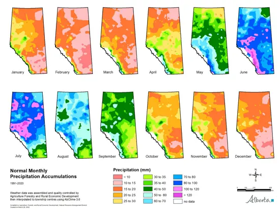
Map 6: The entire province in now entering the wet season, with rainfall totals historically peaking across the south in June, and across the North West and Peace Regions, in July (Map 6). Historically Southern Alberta is particularly vulnerable to overland flooding during June, and most of these events are preceded by overly wet conditions that take time to saturate the land and reduce surface storage capacity. We appear to be 'priming' the land in some areas and vigilance, with an eye-to-the-sky, would be wise. However, a short spell of warm and dry weather would help mitigate this risk. Please note that this is not a prediction for flooding, it is only a reminder to be watchful and prepared in the days and weeks ahead.
Contact Us
Saddle Hills
Junction of Hwy 49 & Secondary Hwy 725
RR1, Spirit River AB
T0H 3G0
T. 780-864-3760
Fax 780-864-3904
Toll-free 1-888-864-3760
frontdesk@saddlehills.ab.ca
Sign up to our Newsletter
Stay up to date on the Saddle Hills activities, events, programs and operations by subscribing to our eNewsletters.


